PuzzleMaze - Confluence Hunting
Confluencing hunting is using a GPS (or detailed map) and attempting to get to integer intersections of latitude/longitude (e.g. 42N 106W) and photographing the spot. Why is this cool?
You get outdoors, you get to discover new and possibly interesting places that don't have tourist trails leading to them, and you can end up with intriguing route choice, map, or physical challenges. The idea of going to a totally arbitrary point on the planet also has intrinsic appeal -- what will be there? -- what will I see and who will I meet on the way? -- what route choice problems will I face and will I improve my navigation skills?
There is also a competitive aspect for some -- once someone has visited a particular point, it is usually not visited again, so it is nice to get there first. As the easy ones are bagged, that simply leaves harder, more interesting, and more prestigious ones, hence leading to more interesting challenges.
Being part of the community effort to bag each such point on the planet is also cool, as the world map of bagged confluences fills in. Check out the project website.
How is this different from geocaching? No bucket or other visible debris, and no guarantee that you will get to the spot. Unlike a waypoint 400 meters from the road, these things can be a challenge to get to, and over time, the scarcity of easy ones increases. And the photography can add an artistic element to the pastime. Also, since there is usually only one visitor to the point, there is no worry about unwanted new trails being beat to the place. Admittedly, some of the points can be pretty lame, whereas with geocaching the placer usually has an interesting point for you to visit. And of course with geocaching, there is always that chance you will find the keys to a Mercedes in the bottom of that bucket ... :-)
I've had the pleasure of finding 6 confluences in 5 countries, including single-handedly completing the country of Luxembourg, (which has one confluence :-))
|
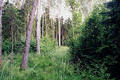
57°N 22°E 4.0 km (2.5 miles) NNE of Kuldiga, Kuldigas Rajons, Latvia |
|
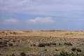
42°N 106°W 12.7 miles (20.4 km) NE of Medicine Bow, Carbon, WY, USA |
|
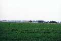
42°N 105°W 4.5 miles (7.2 km) SSW of Wheatland, Platte, WY, USA |
|
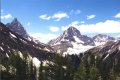
51°N 116°W 32.0 km (19.9 miles) E of Harrogate, BC, Canada |
|
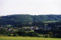
50°N 6°E about 600m from Enscherlange, Luxembourg |
|
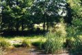
48°N 2°W 3.0 km (1.9 miles) NW of Maxent, Ille-et-Vilaine, Bretagne, France |